For those looking for new ways to explore the great outdoors, mountain biking offers a fun option that’s enjoyable for all ages. As a way to cover longer distances than on foot, mountain biking offers a way to see stunning views in a fun and exciting way.
As outdoor recreation sports grow in popularity, mountain biking is experiencing an explosion in growth and participation. The great part about this is that no matter where you live, you likely live within a short drive of a great mountain biking area. This is especially true for those that live in Nevada, an absolute playground when it comes to mountain biking.
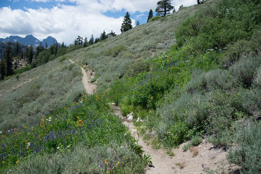
Nevada can, in many ways, be seen as a sort of paradise for mountain bikers of all skill levels. With terrain varying from desert canyons to the foothills of the Sierras, Nevada offers over 1,000 miles of trails for mountain bikers of all skill levels. It offers an array of long, looping desert runs, as well as short, quick technical climbs and descents.
Mountain biking as a beginner can be daunting, however. Once you’ve grasped the basics of handling your bike while on the trail, you’ll still want to make sure you aren’t biting off more than you can chew when it comes to trail choice. Use this list as a guide to choosing a trail in Nevada that meets the skill level of those just getting started.
1 – POW
Located just outside of Boulder City, and a short drive from Las Vegas, the Bootleg Canyon trail system offers some of the best mountain biking in the state of Nevada. With over 35 miles of singletrack trails, Bootleg Canyon offers runs for all skill levels.
The POW trail specifically offers a great downhill ride for beginners. Featuring long sweeping turns, the trail offers a fairly low technicality ride. Beginners will want to be on alert through the middle section, as a fairly steep drop through a rocky stretch could cause problems if it’s taken with too much speed coming in. Otherwise, this is a fairly carefree run.
Marked as an Epic ride by the IMBA, mountain bikers in the Las Vegas area will want to make the day trip to have a go at these trails. The extensive network of trails means riders can easily spend a whole day exploring the area. Shuttles and rentals out of Las Vegas are available, in addition to Boulder City.
2 – Badger Pass Loop
Located in the Blue Diamond area just west of Las Vegas, the Badger Pass Loop is part of a larger trail system that runs north of the 160 highway. The Badger Pass loop is an excellent trail for beginners.
At about 8 miles in length, the first half of this run includes a slow and steady incline. The back side involves a fun and technical descent with great views of the surrounding landscape. Additionally, you can choose to run Badger Pass on its own or as part of a different loop. This offers riders a steady climb over 3 miles of singletrack.
Bikers taking this route can roll it into a longer run by continuing on to Three Mile Smile, listed below. Riders making this run will experience a short, technical descent to the trailhead of Three Mile Smile, but nothing that most beginners can’t handle.
Being so close to the Blue Diamond area, this loop can be part of a morning run before setting out on something longer in the afternoon. This area is very exposed though, so pack a lot of water!
3 – Blue Diamond
Neighboring the Badger Pass Loop, the Blue Diamond trail system offers some of the best high desert mountain biking in all of Nevada. With hard-packed singletrack trails, the roughly 30 miles of trail run fast and provide for excellent runs for bikers of all skill levels.
Visitors to this area can choose between varying degrees of switchbacks on the south side of the ridge that offer excellent views down to Las Vegas, or easier, more level trails on the north side that provide for a less tiresome run. With varying degrees of difficulty throughout the area, Blue Diamond offers beginners an excellent opportunity to test their skills and work their way up the ladder.
Visitors to this area should be sure to pack lots of water, as the days can be hot and water sources are scarce if existent. You also might want to make time for a stop off in the city of Blue Diamond, a modern oasis in the desert.
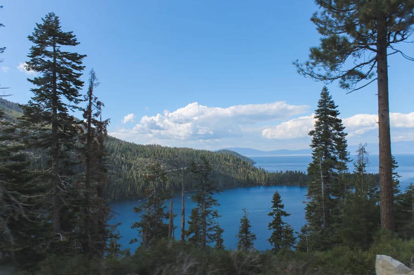
4 – Flume Trail
Leaving behind the desert landscape, Flume Trail takes bikers high above the east shore of Lake Tahoe. Located just outside of Incline Village, Flume Trail offers an intermediate trail that provides riders with stunning views of Lake Tahoe down below.
While the skillset needed to tackle this run isn’t very advanced, you will need a higher tolerance of heights than you might expect. With little in the way of technical features, you’ll find yourself riding across fairly steep slopes with wide open views down to Lake Tahoe.
At roughly 14 miles in length, the singletrack trail offers a fairly challenging incline before getting to the fun parts of the decline and views. Riders looking to do this run will have to take into consideration that the run doesn’t end at the same place it begins. There is a shuttle available to transport riders back to the parking lot near the start, or riders can park one car at each point.
5 – Diamond Peak Loop
Another run located outside Incline Village, Diamond Peak Loop offers riders with an excellent downhill run filled with lots for opportunities for added fun. This run can be completed either as a loop, with a significant climb or as a one-way downhill run. You’ll want to pay attention, as the turnoff to approach the parking lot near the start of the descent can be tricky to find.
Once there, riders will find a descent of about 4 miles that contains a number of varying features and terrain. This can be a great option for beginners looking to improve their descent skills or those that might be adventurous enough to try out the numerous box jumps.
As part of the Incline Village area, Diamond Peak is part of an area that has a ton to offer mountain bikers. Whether you want short and fast runs, or longer, more physically demanding rides, Incline Village can accommodate you.
6 – Beginner Loop
The Beginner Loop is just that, a relatively flat loop that comes in at just under 4 miles. Located in the Blue Diamond area and part of the Cottonwood Valley Trail System, the Beginner Loop is a great option for beginners that are in the Las Vegas area. Just a 40-minute drive, it’s a great option for an easy after work run for those in the Las Vegas Area.
While a relatively easy and flat loop, Beginner Loop offers incredible views of the desert landscape that make it well worth the time. As part of a much larger and expansive trail system, the Beginner Loop can offer an excellent warm up for those that want to move on to bigger and longer runs.
7 – Landmine Loop
Another run located in the Cottonwood Valley Trail System, just outside of Blue Diamond, the Landmine Loop offers riders a longer run that takes them deeper into the CVTS. Similar to the Beginner Loop, this run offers excellent views of the desert landscape outside of Las Vegas.
Running just over 7 miles of singletrack trail, the Landmine Loop does not actually fully connect, though the beginning and end points are only separated by a small neighborhood. This one is also rarely run entirely as listed. Because the CVTS can be so congested in parts and trail signage can lack, riders often just patch together a set of trails to their taste to create a loop.
This gives the beginner a great testing ground for new skills and challenges. You can essentially customize your run to match exactly what you’re looking for that day. Whether you want a long run with little elevation change or a shorter run that’s more technically challenging, the CVTS can help you find it.
8 – Good Call
Cutting down the middle of a larger loop. Good Call offers a short run that allows riders an easier option to reaching the top of the ridge. Designed as a two-way trail, this trail has come to be preferred by riders as a short, fun descent than as a way of climbing up to the ridge.
Located outside of Las Vegas in the Spring Valley area, the trail is part of the Southwest Ridge Trails system. As a downhill run, Good Call is an absolute blast. The trail builds an excellent flow of features and challenges, while still being suitable to beginners. At only 1.8 miles, you’d be forgiven if you feel a desire to circle back up the ridge to make the run again.
This run will give you the sweeping desert views that are typically associated with the areas surrounding Las Vegas.
9 – Ash Canyon to Kings Canyon Trail
Getting out of the Las Vegas area, this trail takes you back to the Lake Tahoe area and Carson City. Running north to south, the trail provides excellent views of Eagle, Washoe, and Carson Valleys.
The trail follows a ridgeline that averages over a mile in elevation. With not much in the way of elevation gain or loss, the run isn’t very challenging from a physicality standpoint. The skill level is rated as intermediate, offering a variety of challenges to test a beginner.
At just over 7 miles of singletrack, this trail is actually a point to point run and doesn’t create a loop in its own right. The Ash Canyon Trails system, however, offers a number of trail options that will allow you to loop back to the starting point. Another option is to ride down into Carson City for a bite to eat and catch a shuttle back to your car.
10 – Tin Can Alley
Another ride located in the Las Vegas area, the Tin Can Alley trail has it all for mountain bikers. Located in the Mt. Charleston area, the trail runs as a point to point ride, running roughly 4 miles in length.
As a point to point run, and as a two-way trail, Tin Can Alley can be ridden in either direction. The most popular, as is the case with almost all trails of this nature, is the downhill ride. Ducking in and out of desert and forest landscape, the trail will keep riders constantly on their toes.
As a popular ride outside of Las Vegas, this trail offers beginners an excellent opportunity to build on their abilities. Constantly changing terrain and environment will help beginners build knowledge on how their bikes will react to various conditions, increasing their confidence when tackling new challenges.
11 – Tahoe Rim Trail – Spooner Summit to Heavenly Mountain
Rated as one of the best mountain biking trails in the western part of the United States, let alone Nevada, the Tahoe Rim Trail offers riders an epic ride high above the eastern shores of the gorgeous Lake Tahoe.
Running point to point, at almost 18 miles this trail offers riders the opportunity to really stretch it out and test their skills. While long and physically challenging, the trail never gets so challenging as to be too much for riders of any skill level.
The trail itself follows your typical High Sierra terrain, open and rocky with scattered tree cover along the way. The section specifically running from Spooner Summit to Heavenly Mountain features almost 3,000 feet of elevation gain and roughly 2,300 feet of descent.
For this section, you’ll either need to arrange for a shuttle or park cars at the beginning and end points. For those feeling extra ambitious, you can continue your circumnavigation of Lake Tahoe along the Tahoe Rim Trail.
12 – Solar Coaster
Located in northeastern Nevada, just an hour outside of the Salt Lake area of Utah, Solar Coaster offers one of the most fun downhill runs in all of Nevada. Starting at roughly 8,000 feet above sea level, the ride drops down over 1,500 feet over the course of just 3.5 miles.
The run is steep and will provide riders with a fun and fast ride. While it gets technical in some areas, most beginners should be capable of handling the challenge. Built as a single track, it’s unlikely you encounter traffic coming in the uphill direction, so can feel free to really let loose.
Beginning higher up in beautiful alpine landscapes, the trail quickly drops down onto a ranch, the owner of which has granted permission to mountain bikers to pass through so long as they close any gates they may have to open. While hikers and uphill bikers may not be a worry, livestock is a possibility, so heads up when you reach the lower section of the trail.
13 – Legalize It
Locate in the Spring Valley area outside of greater Las Vegas area, Legalize It is part of the Southwest Ridge Trails system. Running from the top of the Connect the Dots trail to the top of Ike’s Peek, the trail offers riders a varied ride of inclines and declines that run the length of a ridgeline.
At just 3 miles, the trail is on the short end of those on this list. That said, the Southwest Ridge Trails system offers bikers a number of options in terms of stringing together trails for a longer run or loop. The area offers the full spectrum of difficulty level too, so riders can really tailor their run to their skillset.
The run offers riders with the opportunity to stay on the trail or try out a number of features along it to create an added challenge. No matter how you do it, Legalize It offers great views of Las Vegas and is a joy to ride for bikers of all skill levels.
14 – Tahoe Rim Trail – Mt Rose to Hobart Road
Another segment of the THT, this section similarly offers riders with a gorgeous ride of carrying terrain and landscapes and lots of physical challenge. Clocking in at just under 14 miles, this portion features roughly 1,300 feet of climbing and 1,800 feet of descent.
This section takes the rider away from Lake Tahoe a bit and trades expansive views of the lake for idyllic alpine meadows. Taking bikers through the High Sierra terrain, this section offers a longer, more physically demanding ride, while not overwhelming beginners with overly technical stretches.
Riders will have to arrange for a shuttle back to their car or be sure to park a car at each point, as there aren’t many options for turning this ride into a loop. You’ll also want to be on the lookout for wildlife, as this is bear and mountain lion country.
15 – Marlette Creek Trail
Located in the Lake Tahoe area, Marlette Creek Trail offers riders a great descent down from the Flume Trail to the east shore of Lake Tahoe. A quick run, the ride descends nearly 2,000 feet in the span of only 4 miles. While being a fast-paced run, this trail should be within the capabilities of most beginner riders.
Dropping down off of Flume Trail, Marlette Creek Trail offers a great day trip for riders, as it ends at Chimney Beach. Cutting off of Flume Trail to ride down and spend the afternoon at Chimney Beach is about as perfect a way to spend an afternoon as you can dream of.
From Chimney Beach, the way back is either back up Marlette Creek Trail – a truly brutal climb or by road, which can get a bit sketchy through some stretches. With this in mind, flumetrailbikes.com has you covered by offering shuttles in the Lake Tahoe area. For a reasonable rate they can get you back to your car safely.
16 – Stagecoach Trail
The Stagecoach Trail is another of the shorter runs listed here, though by being located within the Peavine Trails system there are a number of options for riders to create a longer, more challenging run or loop that brings them back to where they began.
Located just outside of Reno, the Stagecoach Trail and Peavine Trails system offers an excellent mountain biking area for those visiting the Lake Tahoe area. Rated as the best trail within the Peavine Trails system, Stagecoach is 1.5 miles of singletrack descent. Where the trail gets its high rating is in the flow of its descent, never unduly disjointing the ride with overly technical features.
Ranging through beautiful highland desert landscapes, Stagecoach and the surrounding Peavine system offer riders with a quintessential Nevada mountain biking experience. With such an expansive system of varying difficulty levels, riders can easily spend an entire day exploring this system.
17 – Girl Scout
Part of the Bootleg Canyon system, these trails are located just outside of Henderson, NV, a suburb of Las Vegas. Riders coming to Las Vegas will find an expansive trail system at Bootleg Canyon that offers the picturesque Nevada desert experience.
Another short run at just 1.5 miles, Girl Scout offers riders a fairly easy and enjoyable descent within the Bootleg Canyon system. While a point to point run, the larger system offers riders a number of possibilities in terms of creating a longer run or looping back to the start point.
While it can be ridden in either direction, the north to south run is the most popular. For riders taking this direction, the West Leg trail offers a great option to loop back to the parking area near the north end of Girl Scout.
18 – Three Mile Smile
Heading back to the Blue Diamond trails system, Thee Mile Smile is actually a bit of a misnomer. Running at almost 5 miles, the trail gives you two bonus miles and makes for a nice ride through the Blue Diamond area.
Dropping roughly 1,000 feet from the north point to the south point, this run can either be an easy decline run from north to south or a challenging south to north ride that steadily climbs the entire way. Taken in either direction, the run never gets very technical, so the choice of direction will come down to what kind of workout you’re looking to get that day.
Unlike the Badger Pass Loop, Three Mile Smile doesn’t create a loop on its own. That said, the extensive trail system of the Blue Diamond area allows riders to find a number of different routes back towards the starting point, allowing riders to customize their runs to whatever length and skill level they might prefer.
19 – Twilight Alternate Cut
The shortest trail on the list, Twilight Alternate Cut is located in the Mt Charleston area, and part of the larger trail network of Mt Charleston in southeast Nevada. Located just a short drive from Las Vegas, this area provides riders with a great Nevada desert experience without having to go too far into the wilderness.
At only one mile in length, the Twilight Alternate Cut offers riders with an alternative route to take on the longer Twilight Zone Loop. Creating a total run of about 10 miles, the Twilight Zone Loop is a popular ride for those visiting the Mt Charleston area. The Twilight Alternate Cut gives riders a route that shortens it a bit and takes them through a Joshua tree forest.
This short downhill cut provides riders with a smooth and relaxing descent through one of the more unique habitats in the southwestern United States. Anyone visiting the Mt Charleston area should strongly consider making a run on it.
20 – Secret Canyon
Another short trail, Secret Canyon is located in the Nanny Creek Trail System in northeastern Nevada. Just a mile long, the trail is a steady climb the entire way, though nothing too daunting for the beginner. The physical challenge is the most difficult part of this trail, as its technical sections are fairly easy.
Taking this trail from east to west will give riders the steady climb, as they move through pinyon pine and juniper forest canopies. Running from House of Paine at its eastern terminus, to Cinder Cone Vista at its western terminus, Secret Canyon is just one trail in an expansive system that is Nanny Creek.
Riders visiting Nanny Creek will enjoy the varying terrain and trail types. Offering slow climbs and fast descents, as well as technical sections, Nanny Creek has a trail for riders of every skill level. Those visiting the area should be sure to make a run on the Secret Canyon Trail.
Anyone visiting Nevada for the mountain biking will have a ton of great options to choose from. The problem might actually come from having too many to choose from! For more information on various trails, along with maps and up to date conditions, visit mtbproject.com.